Monthly TerraClimate in netCDF format
Contents
Monthly TerraClimate in netCDF format#
This section will explain on how to download TerraClimate’s precipitation (ppt) and potential evapotranspiration (pet) monthly data in netCDF format and prepare it as input for SPI/SPEI calculation.
Download TerraClimate data#
There are 2 files contains link for downloading
ppt(Precipitation) andpet(Potential Evapotranspiration).Download both files and put it in the same location with your working directory.
Navigate to
downloads/terraclimate/ppt/nc_originalanddownloads/terraclimate/pet/nc_originalfolder in the working directory. Download all TerraClimate in netCDF format from Jan 1958 to Dec 2020 usingwget(this is lot of data,ppt± 7.7GB andpet± 6.4GB, please make sure you have bandwidth and unlimited data package). Paste and Enter below script in your Terminal.If you are in
downloads/terraclimate/ppt/nc_originalthen execute below command.sh data_ppt.sh
If you are in
downloads/terraclimate/pet/nc_originalthen execute below command.sh data_pet.sh
Extract data based on area of interest#
Next step will be extract data using a bounding box based on area of interest and merge netCDFs into single netCDF.
Note
Below guideline provide example on how to use CDO and NCO to do some data extraction process, you can choose which one is suits you.
Clip your area of interest using bounding box. We will use Sao Tome and Principe (STP) as the example case.
Example: STP bounding box with format
lon1,lon2,lat1,lat2is5.75,8.05,-0.35,2.15.Precipitation: Navigate your location to
/downloads/ppt/nc_original.Software
Script
CDO
for fl in *.nc; cdo sellonlatbox,5.75,8.05,-0.35,2.15 $fl ../nc_subset/"stp_cli_"$fl; doneNCO
for fl in *.nc; ncks -d latitude,-0.35,2.15 -d longitude,5.75,8.05 $fl -O ../nc_subset/"stp_cli_"$fl; donePotential Evapotranspiration: Navigate your location to
/downloads/pet/nc_original.Software
Script
CDO
for fl in *.nc; cdo sellonlatbox,5.75,8.05,-0.35,2.15 $fl ../nc_subset/"stp_cli_"$fl; doneNCO
for fl in *.nc; ncks -d latitude,-0.35,2.15 -d longitude,5.75,8.05 $fl -O ../nc_subset/"stp_cli_"$fl; doneMerge all annual netcdf in a folder into single netcdf.
Precipitation: make sure you are in
/downloads/ppt/nc_subset.Software
Script
CDO
cdo mergetime stp_*.nc ../nc_merge/stp_cli_terraclimate_ppt_1958_2020.ncNCO
Before merging the data, NCO required all the data has
timedimension, we will usenckscommand to maketimethe record dimension/variable used for concatenating files. Then usencrcatto concatenate it.for fl in *.nc; do ncks -O --mk_rec_dmn time $fl $fl; donencrcat -O -h stp_*.nc ../nc_merge/stp_cli_terraclimate_ppt_1958_2020.nc
Potential Evapotranspiration: make sure you are in
/downloads/pet/nc_subset.Software
Script
CDO
cdo mergetime stp_*.nc ../nc_merge/stp_cli_terraclimate_pet_1958_2020.ncNCO
Before merging the data, NCO required all the data has
timedimension, we will usenckscommand to maketimethe record dimension/variable used for concatenating files. Then usencrcatto concatenate it.for fl in *.nc; do ncks -O --mk_rec_dmn time $fl $fl; donencrcat -O -h stp_*.nc ../nc_merge/stp_cli_terraclimate_pet_1958_2020.nc
Check variable and attribute#
As explain in above step, we need to check the variable and attribute on above result to make sure all meet the requirements.
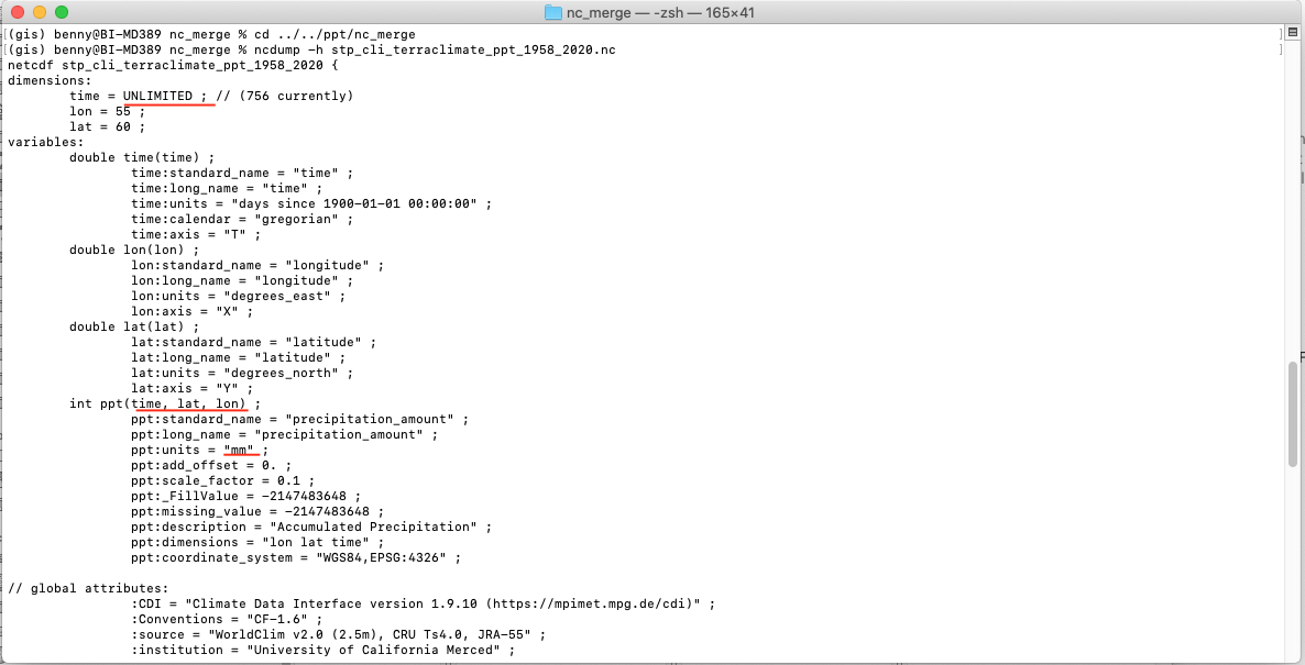
Navigate to
/downloads/ppt/nc_mergefolder in the working directory. Then execute below command.ncdump -h stp_cli_terraclimate_ppt_1958_2020.nc
Navigate to
/downloads/pet/nc_mergefolder in the working directory. Then execute below command.ncdump -h stp_cli_terraclimate_pet_1958_2020.nc
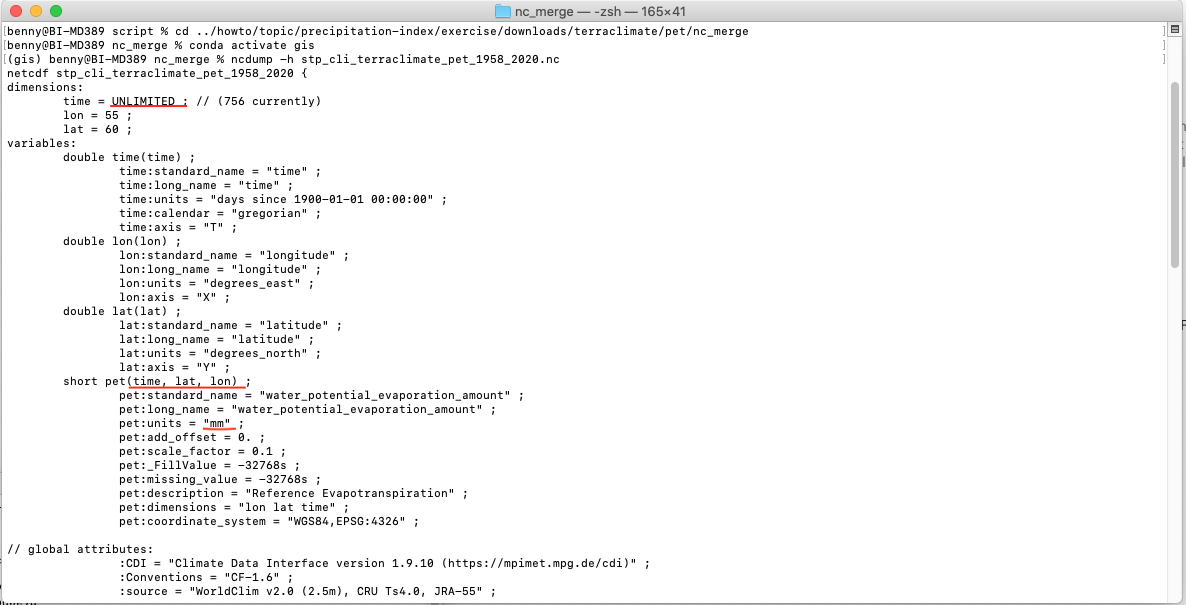
As you can see from above picture, all the requirement is completed: unit is in
mm, order dimension for each variables islat,lon,time, andtimedimension is inUNLIMITED. Once this has completed, the dataset can be used as input toclimate-indicespackage for computing SPI/SPEI.